NISAR Mission: A New Era of Earth Observation and Global Collaboration
NISAR, a groundbreaking NASA-ISRO Earth-observation satellite, revolutionizes global monitoring with dual-frequency radar. Providing all-weather, high-resolution data, it tracks Earth’s changes from quakes to ice melt while symbolizing international collaboration and open scientific access

In an age of increasing climate uncertainty, rapid urban expansion, and intensifying natural disasters, the world has never been more in need of real-time, high-resolution, and reliable Earth observation systems. Answering that call is one of the most ambitious and advanced space collaborations of the 21st century: the NISAR mission.
NISAR, which stands for NASA-ISRO Synthetic Aperture Radar, is a joint Earth observation mission between the United States space agency NASA and India’s premier space research body, ISRO. This mission represents the culmination of over a decade of research, engineering, diplomacy, and shared vision. It marks a technological first the deployment of the world’s first dual-frequency synthetic aperture radar satellite designed to observe Earth’s land and ice surfaces with unmatched accuracy.
Why NISAR Matters
NISAR is more than just another satellite in orbit. It is a scientific breakthrough with profound implications for how we monitor, understand, and respond to Earth’s dynamic systems. This satellite will enable scientists, researchers, governments, and emergency responders to detect and analyze the slightest changes on the Earth's surface sometimes as small as a centimeter.
From tracking the slow creep of glaciers and rising sea levels to observing land subsidence in megacities and shifts in agricultural land use, NISAR will serve as a critical eye in the sky. But beyond its technical capability, NISAR also symbolizes an evolution in global partnerships. By combining the engineering might and space experience of NASA and ISRO, the mission signifies the increasing interconnectedness of our global scientific endeavors.
Anatomy of the NISAR Satellite
At the heart of the mission is the NISAR satellite itself, a marvel of modern engineering. Unlike traditional Earth observation satellites, NISAR carries two radar systems an L-band system developed by NASA and an S-band system developed by ISRO. These radars work at different frequencies, enabling the satellite to collect complementary data sets that reveal a fuller picture of Earth’s processes.
The L-band radar, with its longer wavelength, penetrates deep into forest canopies, snow, and even the upper layers of soil and ice. This makes it ideal for monitoring vegetation structure, ice sheet dynamics, and groundwater changes. The S-band radar, with its shorter wavelength, is more sensitive to surface-level features and will provide detailed imagery of changes in urban areas, agricultural fields, and wetlands.
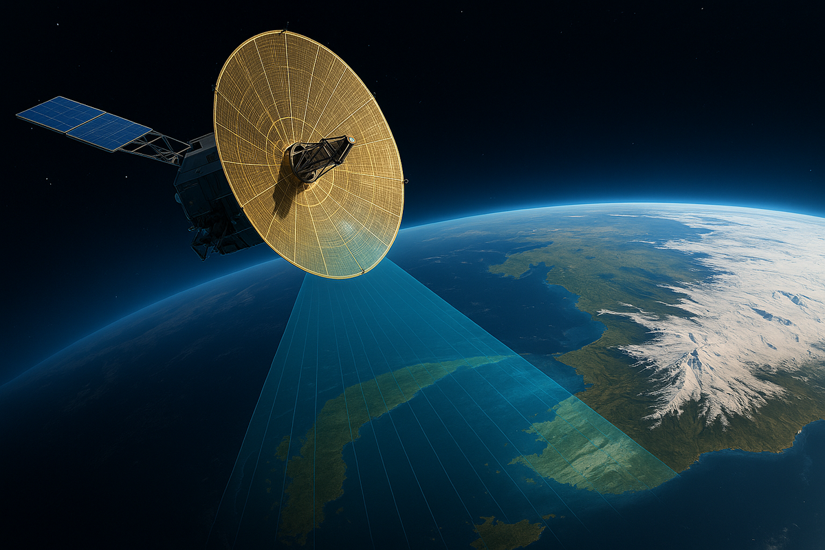
One of the most visually striking features of the satellite is its 12-meter diameter radar reflector antenna. This large golden mesh dish, which unfolds like a flower once the satellite reaches orbit, allows NISAR to sweep a vast swath of Earth’s surface with each pass, capturing high-resolution imagery across a wide area.
Technical Features and Capabilities
- Orbit and Coverage: NISAR will operate in a near-polar sun-synchronous orbit, allowing it to scan nearly the entire globe every 12 days. The satellite completes about 14 orbits per day, providing frequent and consistent observations.
- Spatial Resolution: With its dual-frequency radar, NISAR can achieve a spatial resolution of 5 to 10 meters, depending on the mode of observation. This enables detection of minute ground movements and fine-scale environmental changes.
- Swath Width: NISAR’s radars will cover a swath width of approximately 240 kilometers, making it one of the widest radar coverage systems in operation. This wide reach enhances its ability to monitor large-scale changes in regions like the Amazon rainforest or the Arctic ice cap.
- All-Weather, Day-Night Imaging: Unlike optical satellites that depend on sunlight and clear skies, NISAR’s radar systems can operate in all weather conditions and during both day and night. This ensures uninterrupted data collection regardless of atmospheric conditions.
- Open Data Policy: Perhaps one of the most impactful aspects of the mission is its commitment to open access. All data collected by NISAR will be made freely available to the global scientific community, policy-makers, and public stakeholders.
Mission Objectives: Earth in Motion
The Earth is constantly moving tectonic plates shift, glaciers flow, forests grow and recede, cities expand, and rivers meander. NISAR’s primary mission is to measure these changes with incredible detail and consistency. Let’s explore the key domains where NISAR will make a transformative impact:
1. Tectonic and Seismic Activity
Earthquakes and volcanic eruptions are among the most destructive natural disasters. NISAR’s ability to detect tiny ground deformations over time makes it a powerful tool for understanding seismic zones. It can monitor fault lines and detect subtle movements that may precede a major seismic event. This information can be used to develop better early warning systems and risk mitigation strategies.
2. Glaciers and Ice Sheets
Melting glaciers and polar ice sheets are among the most visible and alarming signs of climate change. NISAR will map and measure changes in ice mass in Greenland, Antarctica, and the Himalayas with high precision. These observations are critical for understanding sea-level rise and its potential impacts on coastal populations.
3. Land Subsidence and Urban Infrastructure
Rapid urbanization, excessive groundwater extraction, and underground mining can cause land subsidence, leading to structural damage in cities. NISAR can track ground-level changes in cities like Jakarta, Mexico City, and Delhi, providing valuable data for urban planners and infrastructure maintenance.
4. Agriculture and Food Security
In agriculture, knowing when, where, and how crops are growing is vital for food security. NISAR can detect changes in soil moisture, crop growth cycles, and irrigation patterns. This data supports more efficient farming practices, drought management, and yield predictions.
5. Forests and Carbon Accounting
Forests act as carbon sinks and are vital for regulating the Earth’s climate. Deforestation, forest degradation, and regrowth can now be monitored continuously using NISAR’s radar. This enables countries to better track their progress under global carbon agreements like the Paris Accord.
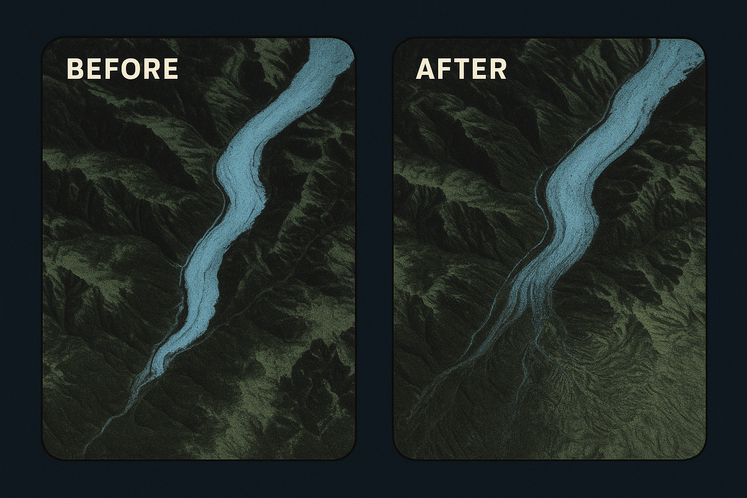
6. Floods, Landslides, and Disasters
Natural disasters often strike without warning, but NISAR can be an invaluable tool in both early detection and post-disaster assessment. By detecting land shifts, water levels, and surface disruption, it can help authorities better respond to floods, landslides, and hurricanes.
Collaboration Beyond Borders
One of the most remarkable aspects of the NISAR mission is the collaboration between two spacefaring nations with very different histories and capacities. NASA brings decades of experience in deep-space exploration and radar technology. ISRO contributes with its rapidly growing launch capabilities, satellite bus systems, and successful track record of cost-effective space missions.
The partnership showcases how countries can pool their strengths to achieve something greater than the sum of its parts. Engineers from both agencies have worked across time zones, cultures, and continents to design, test, and assemble the satellite. The integration of NASA’s L-band radar and ISRO’s S-band radar required extraordinary technical coordination, culminating in the successful launch of NISAR.
This partnership also lays the groundwork for future missions. As geopolitical tensions ebb and flow, scientific collaboration like NISAR demonstrates the enduring value of international cooperation in solving global problems.
The Data Revolution
With the launch of NISAR, we are entering a new era of Earth data. The satellite will generate massive amounts of data terabytes per day. These data will be processed using cloud-based platforms and made available to users around the world. From research institutions and environmental NGOs to government agencies and disaster response teams, a diverse set of stakeholders will benefit from near real-time access to actionable insights.
Data collected by NISAR can be layered with other geospatial data, such as satellite imagery, census maps, and weather forecasts, to create rich, multidimensional analyses. This fusion of data can power advanced tools such as AI-driven predictive models, dynamic climate simulations, and hyperlocal planning systems.
Looking Ahead: A Planetary Perspective
What sets NISAR apart from other satellites is its ability to see Earth not just as a static surface but as a living, moving organism. It doesn’t just take pictures; it tells stories. Stories of ancient glaciers on the move, of coastal lands shrinking millimeter by millimeter, of farmers battling drought in real-time, and of forests breathing carbon in and out with the seasons.
This ability to chronicle change makes NISAR more than a technological feat — it is a narrative instrument. It offers humanity a clearer picture of where we’ve been, where we are, and where we might be headed. In doing so, it empowers us to make informed decisions about our collective future.
The implications of the NISAR mission are vast. For the scientific community, it provides a new lens through which to explore Earth systems. For policy-makers, it delivers crucial evidence for decision-making. For educators, it inspires a new generation of scientists and global citizens. And for the average person, it offers a sense of connection to the living, changing planet beneath our feet.
Conclusion: Watching the World, Together
NISAR stands as a testament to human ingenuity and cooperation. At a time when the world is facing increasingly complex and interconnected challenges, missions like this show what we can achieve when we work together across borders and disciplines.
This satellite is not just watching the world from above; it is inviting the world to watch itself. It is reminding us that we are all part of a shared system, where every glacier, every forest, every tremor, and every field is connected. As NISAR begins its journey across the skies, circling Earth and capturing its secrets, it carries with it the hopes of scientists, the dreams of space explorers, and the shared responsibility of a planet in motion.
In the skies above, a golden radar dish turns, scans, and listens. It hears the heartbeat of Earth. And now, so do we.
For more legal exposes and truth-behind-glamour stories, subscribe to AllegedlyNewsNetwork.com